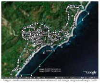
 Con el objetivo de levantar con GPS de todas las viviendas, su ubicación y referencias a fin de poder hacer más fácil el censo de familias próximo a implementarse. Se concluyo con la geroreferenciacion de las viviendas. Esto se realizo en las localidades de La Ciénaga (casco urbano, incluyendo Fudeco) por Rudy Mil Medina, Oklan Guevara Díaz y Alejandro Feliz Montilla.
Para esto se dividió la comunidad en 17 zonas, se marcaran los vectores (limites de zona) son GPS y se distribuyo el trabajo lográndose el levantamiento de unas 833 viviendas de es Municipio de Cienaga (incluidas viviendas en construccucicon y desahabitadas. El tiempo aproximado del levantamiento en horas diarias es de 12 horas por días (divididas en 2) aproximadamente, con una duracion de 16 dias de trabajo.
Ver Informe y Bitácora aquí informe levantamiento casas GEO en pdf.
